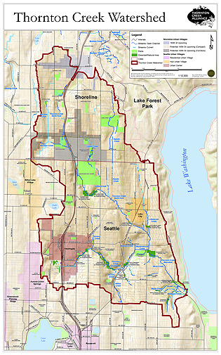
Seattle and Shoreline’s Thornton Creek Watershed
Thornton Creek drains a 7,402-acre (11.6 sq. mile) urban watershed in northwestern King County. The Thornton Creek watershed extends roughly between Puget Sound and Lake Washington, extending from NE 190th St. in the City of Shoreline to NE 80th St in the City of Seattle. Thornton Creek enters Lake Washington at Matthews Beach Park, and Lake Washington drains by way of the Lake Washington Ship Canal to Puget Sound.
The watershed is full of contrasts: large, mature conifer forest in Hamlin Park and the busy stretch of Interstate-5 adjacent to the Northgate Mall area; steep ravines and gently sloped floodplains; dense multi-family neighborhoods near retail cores such as Lake City and neighborhoods with large wooded lots.
Over the last 150 years, the watershed’s native forest has been replaced by urban development. An estimated 75,400 people live in the watershed, and thousands more work there. The watershed is also home to a variety of wildlife and plant species and remnants of once abundant salmon runs.
Unlike other urban watersheds, over 90% of the creek’s main channel – more than 15 miles – flows above ground, through more than 700 backyards and over 15 parks and natural areas, on its way southeast across town toward Lake Washington.
Despite the urban location of the Thornton Creek watershed, it contains many large trees as well as green spaces and parks that provide respite from urban pressures. Residents enjoy spotting blue herons and an occasional bald eagle; and a few salmon still return to spawn in the creek. Beaver, coyotes, raccoons, river otters and possums coexist within this urban setting.
Historically, the watershed was Native American land, and is part of the ceded land and current interest of the Muckleshoot Indian Tribe. The Muckleshoots are co-managers of the fisheries throughout the watershed. Learn more about them here: http://www.muckleshoot.nsn.us/


